Mean State
Download Data |
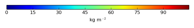
Period Mean (original grids) [Pg] |
Model Period Mean (intersection) [Pg] |
Model Period Mean (complement) [Pg] |
Benchmark Period Mean (intersection) [Pg] |
Benchmark Period Mean (complement) [Pg] |
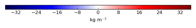
Bias [kg m-2] |
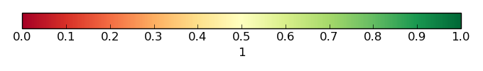
Bias Score [1] |
Spatial Distribution Score [1] |
Overall Score [1] |
|||
|---|---|---|---|---|---|---|---|---|---|---|---|---|
| Benchmark | [-] | 1.38e+03 | ||||||||||
| CESM2_202_01 | [-] | 1.12e+03 | 1.02e+03 | 94.4 | 1.32e+03 | 55.3 | -1.37 | 0.59 | 0.20 | 0.40 | ||
| CESM2_227_01 | [-] | 1.03e+03 | 971. | 59.8 | 1.32e+03 | 55.3 | -1.82 | 0.59 | 0.24 | 0.42 | ||
| CESM2_297_01 | [-] | 1.01e+03 | 953. | 54.4 | 1.32e+03 | 55.3 | -1.96 | 0.60 | 0.36 | 0.48 | ||
| CLM45BGC | [-] | 955. | 938. | 16.1 | 1.32e+03 | 56.4 | -2.05 | 0.61 | 0.86 | 0.73 | ||
| LENS1 | [-] | 548. | 540. | 7.30 | 1.32e+03 | 56.4 | -5.21 | 0.57 | 0.48 | 0.52 |
Temporally integrated period mean